| Older Posts |
All Of The Developments On Boyers Road |
|
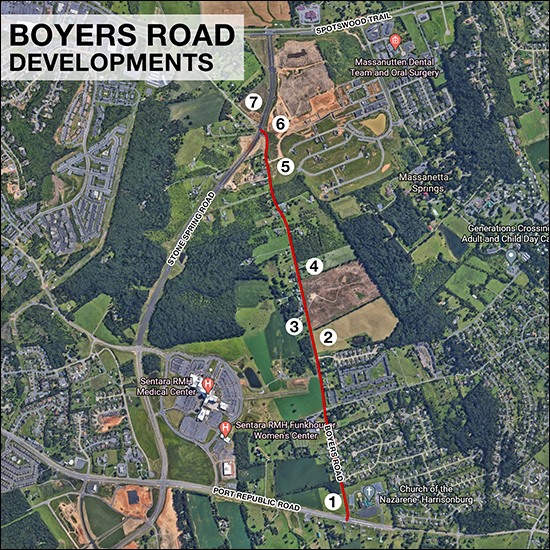
Have you heard about that new development on Boyers Road? There are quite a few of them!
Those are all of the major developments I'm aware of along Boyers Road - but who knows what else is to come along this increasingly busy corridor! | |
Advanced (and fun) Mapping Techniques with the Rockingham County GIS |
|
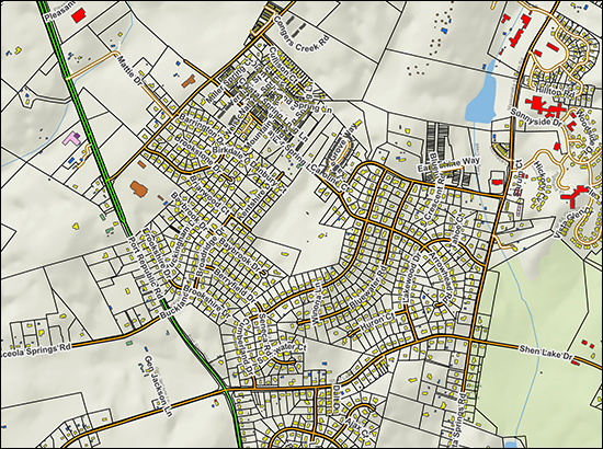
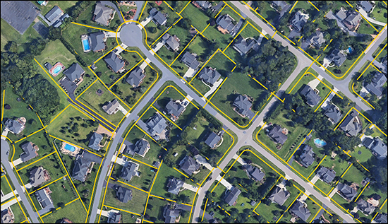 The Rockingham County GIS (geographic information system) is run by InteractiveGIS and they pointed out a fun feature to me recently... In a nutshell, you can select a bunch of parcels (properties) in the GIS and export those property lines from the GIS and then import them to Google Earth! The image above is the result of this export and import process. Now, you might note that the GIS already allows you to see an overlay of property lines on top of an aerial image -- but moving the property lines over to Google Earth allows you to have a 3D view with property lines -- and to interact with it, zooming and panning, and doing all the fun things you can do in Google Earth... 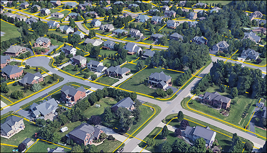 Here's how to do this, in a nutshell... Rockingham County GIS
Google Earth
Give it a try and let me know if you need help making use of this cool functionality in our local (Rockingham County) GIS. | |
Rockingham County Launches New GIS (Geographic Information System) |
|
Rockingham County has launched a new GIS (Geographic Information System) and it's pretty fun. Check it out here... Below are a few features I've discovered so far, and I'm sure there are even more interesting ways to use it to understand properties in Rockingham County. The aerial imagery is now from 2019 (instead of 2018) showing more recent development more accurately... 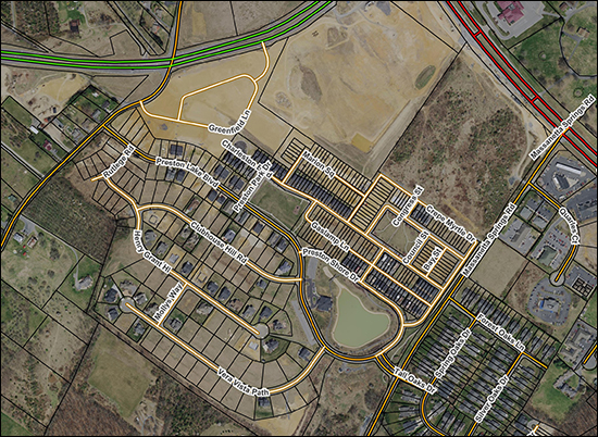 You can turn on the Lake Shenandoah Stormwater Control Authority to see if a property falls within this newly defined area with a new planned tax for addressing stormwater issues in this area... 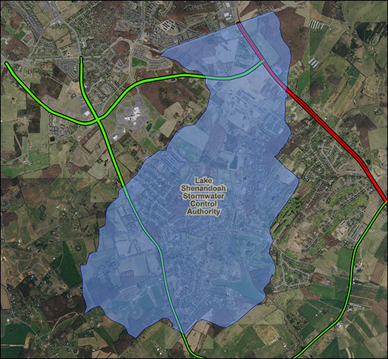 You can turn on 10 foot contour lines to better understand the lay of the land, so to speak, and to see how quickly the elevation of a parcel is changing... 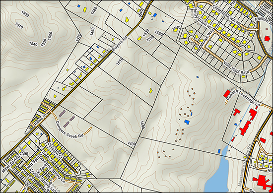 You can turn on a zoning layer to quickly understand how different parcels are zoned in any particular part of the County... 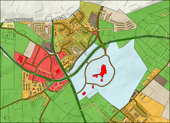 There is even a "land cover" layer that can give you a sense of whether parcels are covered with grass, trees, etc. 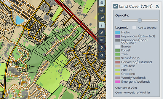 Check it all out at the link below and let me know of any further cool features you discover... | |
What Is Being Developed Where in the Rockingham County Urban Development Area as of October 2019 |
|
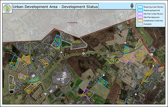
Rockingham County publishes this map each month with the status of developments within the Urban Development Area. Download a PDF of the Oct 2019 version here. Much, but maybe not all, of the stated developments are likely on your radar... Likely or Possibly Coming Soon at Stoneport:
Likely or Possibly Coming Soon on Boyers Road:
You'll find a few other odds and ends as well. Download a copy (here) and see what is under development or proposed to be developed. | |
A Map of Every Building in Harrisonburg and Rockingham County (and in America!) |
|
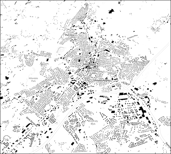
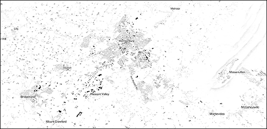
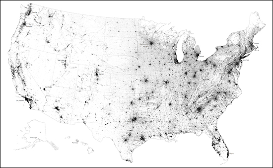
Here's a fun/cool resource to check out in your free time... The New York Times published an online, interactive map of every building in the United States! Each building is represented by a black box spec on the map. Here's another, wider view of our area... Check out the actual article over at the New York Times for extensive analysis, commentary and other map examples. For example... "Where buildings are clustered together, in downtowns, the image is darker, dense. As suburbs stretch out with their larger lawns and malls, the map grows lighter. Your eye can follow the ways that development conforms to landscape features like water and slopes." Oh, and here's the entire country... Find the full article and commentary over at the NY Times here... | |
Updated City GIS Mapping System |
|
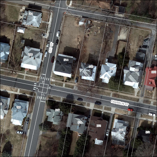 The City of Harrisonburg just launched an updated GIS system, and it's worth checking out the next time you are trying to explore a property in the City of Harrisonburg. One of my favorite parts of the new GIS system is that it is mobile-friendly and you can explore property data much more easily from your phone or tablet. Here is the GIS system: http://www.HarrisonburgVA.gov/GIS Here is the update from the City.... The City of Harrisonburg's Geographic Information System (GIS) recently improved its mapping system and GIS viewer online to allow for more capabilities. The City's GIS technology combines layers of information to give the public a better understanding of a specific area. Different layers of information can be combined to tell a story about that piece of property. Some layers include streets, public facilities, parks, property lines, and city limits. Information about specific parcels of property is also available through the GIS system. The improvements to the City's GIS system have enabled it to be more user friendly and responsive, which allows it to work on a desktop computer or smartphone. When the data and maps are updated, it will be reflected online almost immediately. "The GIS system is a resource that holds a wealth of information, which is free and accessible to the public," explained Nate Rexrode, GIS Administrator. "We encourage members of the public to take a look at the site and utilize the information that is available to them." Property owners are encouraged to visit the GIS site for zoning information, acreage, voting and school districts, and data specifically involving their property. This site is also beneficial for realtors, surveyors, engineers, planners, and those who often research property-related information. | |
How should land just outside Harrisonburg, in Rockingham County, be used in the future? |
|
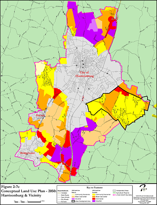 Just as there is a land use guide for the City of Harrisonburg, there is also a Conceptual Land Use Plan for many areas of Rockingham County. Above, I have included the Conceptual Land Use Plan for the areas just outside Harrisonburg (but in Rockingham County) for the year 2050. You can find many more maps -- showing different time frames, and different areas of the County -- on the County's comprehensive plan website. Of note, as you glance at the map above (or this PDF) you might note that the bright yellow regions are intended to be developed for residential use. It is not surprising that the largest contiguous section of such land is just East of the City, in what is referred to as the Urban Development Area. Industrial uses seem to largely be focused just North of the City and just South of the City. Enjoy exploring many more maps here. | |
How should land in Harrisonburg be used in the future? |
|
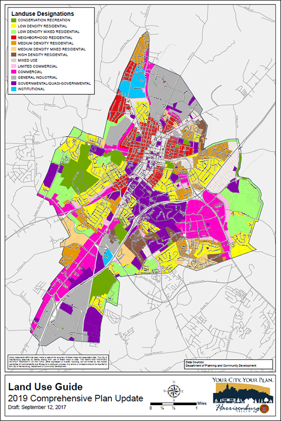 There's a map for that, it seems! Check out the Draft Comprehensive Plan (chapters) for the City of Harrisonburg where you'll find all sorts of interesting maps, including:
The Land Use Guide (draft for inclusion in the 2019 comprehensive plan is shown above) recommends future land uses, but is not regulatory. That is to say that if a piece of undeveloped land is zoned for residential use, but is shown in a "Mixed Use" area in the Land Use Guide map, then staff would likely look favorably upon a future request for rezoning to a mixed use designation. Check out all of the draft chapters of the Comprehensive Plan here. | |
What is being developed at the corner of Stone Spring Road and Spotswood Trail? |
|
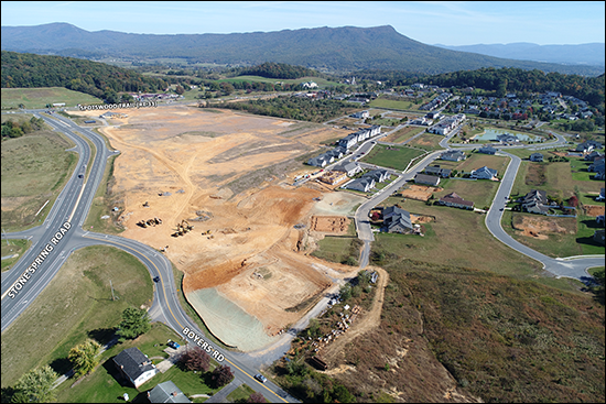 download a larger version of this photo here Just driving by, you might not realize the extent of the mass grading that is currently underway on the corner of Stone Spring Road and Spotswood Trail. The photo above should put it into perspective. This is a LOT of land that is being leveled and prepared for development. But for what, you might ask? A good chunk of it will be used for apartments, it seems -- and the balance for future commercial development. Below is my understanding of the intended use of the space.... 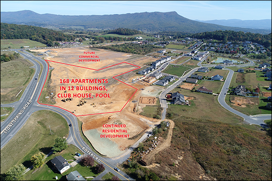 download a larger version of this photo here My understanding of this intended usage of this land is based on the Preston Lake master plan as shown below, updated as of December 2016.... 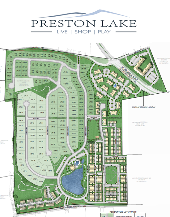 The area that is currently being graded will include the area shown below surrounded by a dashed line. This will include 168 apartments in 12 buildings, as well as a clubhouse and pool. 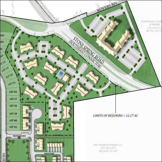 Part of the land being graded in the aerial photo at the top of this post is intended to be used for future commercial development. So, who owns all of this land?
As it pertains to the 168 apartments.... "State Corporation Commission records list William Park of Charlottesville as the registered agent for Mid Town Square. Park is co-owner of Park Properties Management and president of Pinnacle Construction & Development Corp., which builds the apartments."The article went further to identify other complexes in this region that are owned and managed by Park's companies.... "Park's companies are behind two complexes in the area.Digging even further into my archives, I am finding that in the original packet for the proposed approval of the updated Preston Lake master plan (now approved) the engineer for the Preston Lake developer indicated that the apartment buildings are intended to be 2-stories in height. There are also quite a few additional details in that development packet as it pertains to proffers made by the developer when this updated master plan was approved. | |
Proportional Senior Population Increasing in County, Decreasing in City |
|
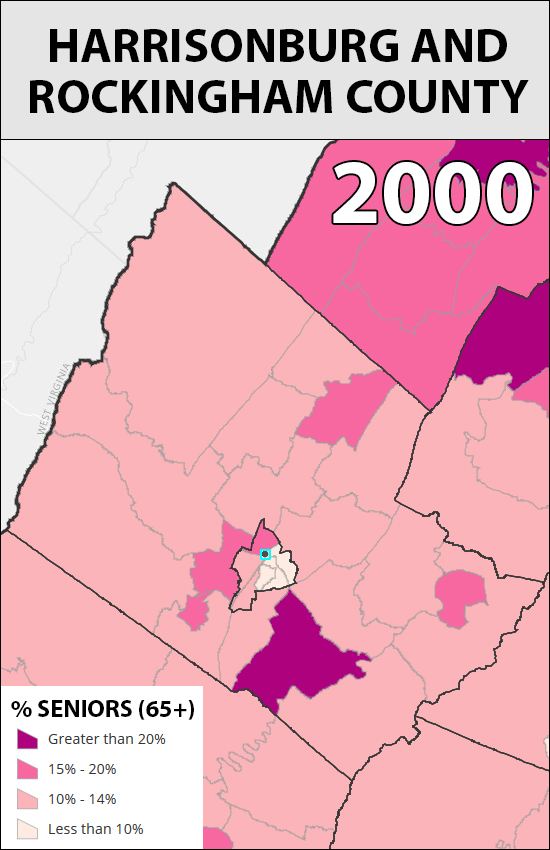 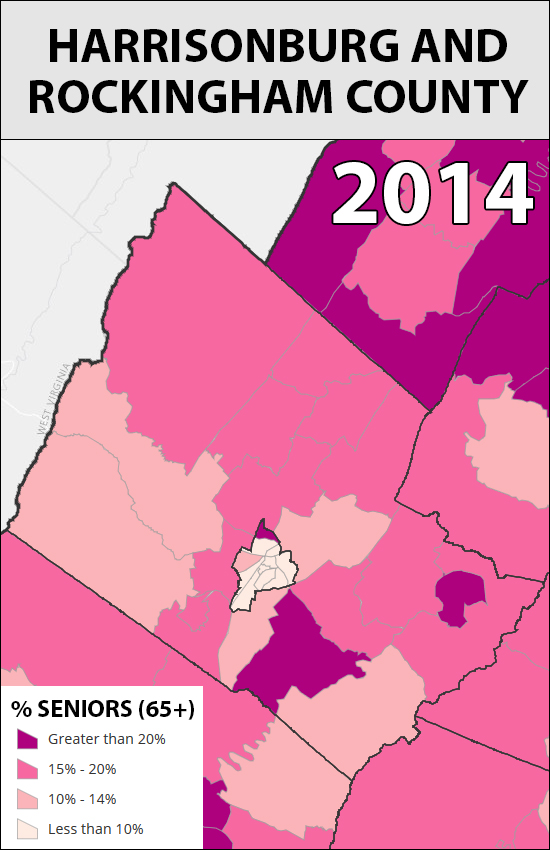 The two maps above were generated here based on changes between 2000 and 2014 in the senior population -- those age 65 or greater. A few observations and thoughts....
| |
JMU property ownership in the Maplehurst neighborhood |
|
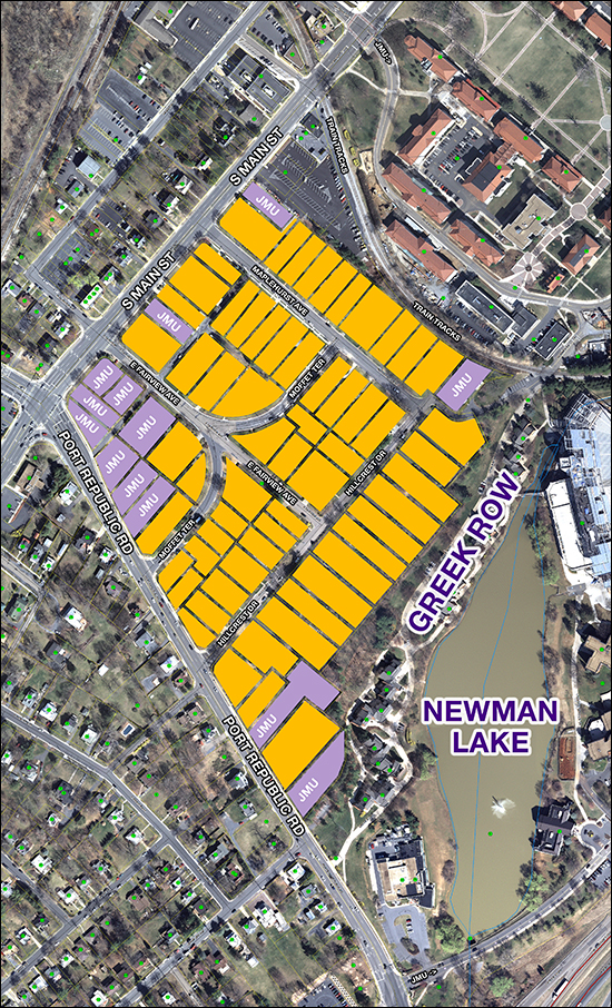 Perhaps not quite as interesting (or pervasive) as JMU's ownership in the Forest Hills neighborhood -- but interesting nonetheless. This is another older residential neighborhood adjacent to the JMU campus. It will be interesting to see over time if JMU purchases more of these homes as another potential direction in which to expand the campus. Thus far, their focus seems to be mainly on the corner of South Main Street and Port Republic Road. Download a larger (23MB) map here. | |
JMU property ownership in the Forest Hills neighborhood |
|
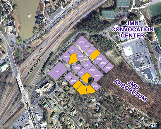 Download a larger (21MB) version of this map here. This past Spring, JMU's student newspaper (The Breeze) published a very informative article about the Forest Hills neighborhood.... JMU purchases most of neighborhood for over $4 million Some pertinent excerpts from that article follow....
(the Breeze article as a PDF can be found here) | |
Both East and West of Town are the Best Spot to Live! |
|
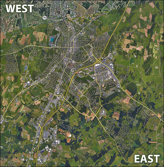 If you have lived in Harrisonburg for a while (more than a few years) which side of I-81 do you live on? The East or the West? Would you consider moving to the other side of I-81? Regardless of which side you are on now, I'm guessing you wouldn't flip-flop to the other side. Most people stay on one side of I-81 after they buy on that side -- because they get used to the patterns of life on that side of our community. Nothing is necessarily better or worse on one side or the other -- but they are different, that's for sure. EAST: Most of the residential development over the past 15 to 20 years has been on the East side of Harrisonburg, in the general vicinity of the new hospital. This makes it an exciting place to live -- for some people. There are many newer developments where homes have recently been built, and there are newer commercial destinations (Stone Port, Martin's grocery store, Target, etc) all on the East side of town. But this also makes it a bit more hectic for getting around. Of note, there is also plenty of outbound traffic East of town, towards Massanutten, Elkton, Charlottesville, etc. WEST: There hasn't been as much residential development West of Harrisonburg over the past 15 to 20 years (other than Belmont and Monte Vista Estates) and this is just fine with most people who live on the Western side of Harrisonburg. Things are a bit calmer, without as much hustle and bustle, and in some cases with more established neighborhoods. The towns of Dayton and Bridgewater end up falling into this side of town as well for many people. I am not doing justice to all of the differences between the East side of town and the West side of town, but I believe that most people in this area are oriented towards one side of town or the other, for very specific reasons. Furthermore, most people who have spent any considerable amount of time living on one side of Harrisonburg likely wouldn't think about moving over to the other side of Harrisonburg. | |
Master Plan for Sentara RMH Medical Center |
|
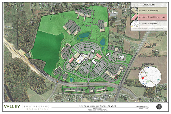 click here for a larger, clearer PDF Sentara RMH has applied for a rezoning of their 238.61 acre campus from B-1C (General Business District with Conditions) to PMR (Planned Medical and Research). In a nutshell, the original rezoning of the hospital campus took it from A-2 (agricultural) to B-1C, which was the most appropriate zoning at the time. Since that time, the County has adopted a revised zoning ordinance that includes this new "Planned Medical and Research" classification. This new zoning district (PMR) is "designed to provide flexibility for large-scale medical facilities and to promote the mixture of uses and increase density of development." So -- nothing to wild or crazy with the rezoning -- seems to be appropriate re-alignment of the zoning of the property with the current and planned future use. The fun part (to me, I suppose) is the updated MASTER PLAN provided as a part of the rezoning request. This paints a picture of how the campus may continue to develop in future years. Download: | |
Explore Harrisonburg History through Sanborn maps of 1886, 1912, 1930 |
|
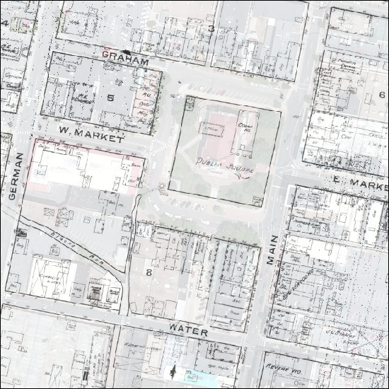 As excerpted from the Feb 27, 2016 article in the Daily News Record.... A website developed by two James Madison University staff members may teach Harrisonburg residents a thing or two about their city. [...] Visitors to the site [...] might learn Liberty Street was named German Street before World War I. They might discover a tannery once stood where the Water Street parking deck now is, or that the county courthouse was less than half its size 130 years ago.Read the full DNR article here, or start explore Harrisonburg's history via the new website.... http://www.gtsc.jmu.edu/shps/map/Enjoy! | |
Where to buy an investment property to be rented to JMU college students |
|
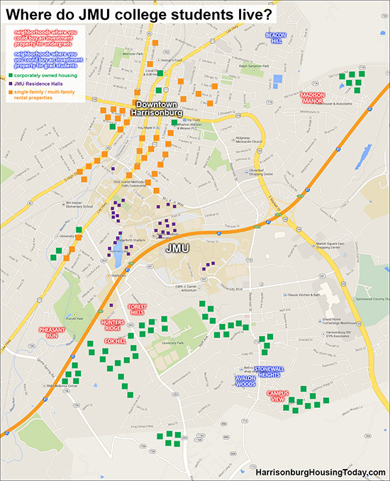 click here for a larger version of the map or here for a PDF The map above shows where JMU college students live, in a few categories of housing....
If you are interested in purchasing an investment property in Harrisonburg, you may want to check out HarrisonburgInvestmentProperties.com -- or, feel free to drop me an email (scott@HarrisonburgHousingToday.com) and we can discuss the best opportunities for you. | |
Nice look at layout of Hotel Madison, Madison Hall, Mason Street Parking Lot |
|
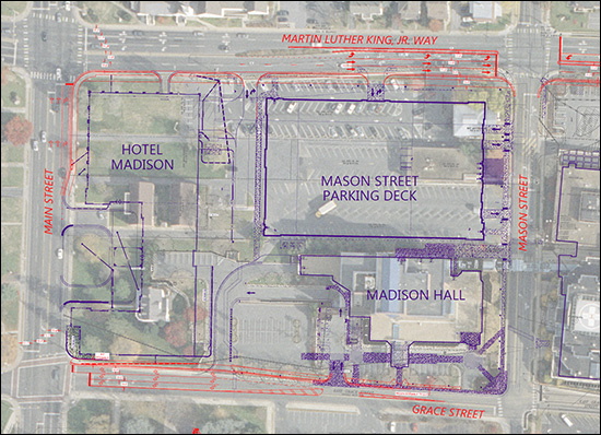 click here to view a larger version This (above) is a nice view of the intended building layout in the quadrant bounded by Main Street, Martin Luther King, Jr. Way, Mason Street and Grace Street. The Mason Street Parking Deck is currently in the early (very early) stages of construction. Madison Hall exists, but will be renovated. Hotel Madison is yet to be started. | |
Commercial and Residential Growth in Rockingham County |
|
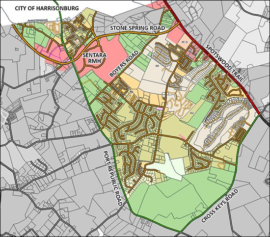 click here for a slightly larger version of this map The location of the still relatively new Sentara RMH Medical Center, the completion of Stone Spring Road (the SouthEast Connector), and zoning maps that are currently being updated have all positioned the area shown above (in color) to be the area where we will see the most commercial and residential growth over the next 5 to 10 (to 20?) years. I used to consider this road to be bound by Boyers Road, Spotswood Trail, Cross Keys Road and Port Republic Road, but Stone Spring Road has certainly reshaped the borders relative to Boyers Road as well as Port Republic Road. Stay tuned for lots of new growth of businesses and homes in this area. | |
The Great East West Divide of Harrisonburg (and Rockingham County) |
|
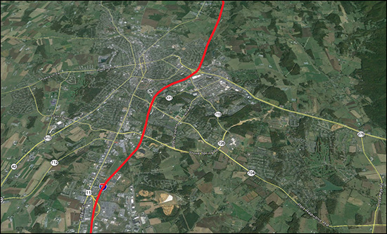 click here to view this map as a larger image A few questions for ya....
EAST: Most of the residential development over the past 15 to 20 years has been on the East side of Harrisonburg, in the general vicinity of the new hospital. This makes it an exciting place to live -- for some people. There are many newer developments where homes have recently been built, and there are newer commercial destinations (Stone Port, Martin's grocery store, Target, etc) all on the East side of town. But this also makes it a bit more hectic for getting around. Of note, there is also plenty of outbound traffic East of town, towards Massanutten, Elkton, Charlottesville, etc. WEST: There hasn't been as much residential development West of Harrisonburg over the past 15 to 20 years (other than Belmont and Monte Vista Estates) and this is just fine with most people who live on the Western side of Harrisonburg. Things are a bit calmer, without as much hustle and bustle, and in some cases with more established neighborhoods. The towns of Dayton and Bridgewater end up falling into this side of town as well for many people. I am not doing justice to all of the differences between the East side of town and the West side of town, but I believe that most people in this area are oriented towards one side of town or the other, for very specific reasons. Furthermore, most people who have spent any considerable amount of time living on one side of Harrisonburg likely wouldn't think about moving over to the other side of Harrisonburg. | |
The End of an (AREA) Era |
|
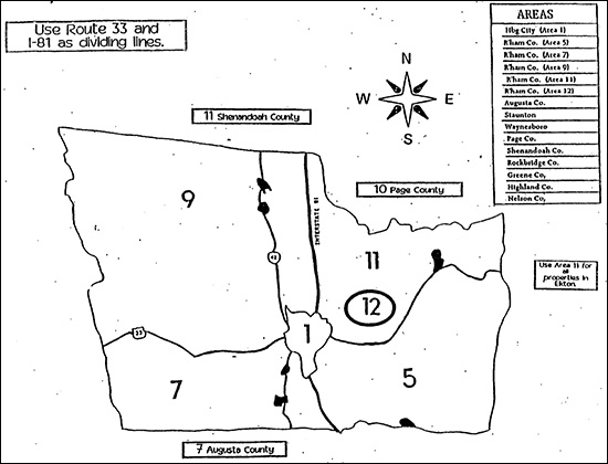 Our local MLS provider just changed, and it has brought about a number of changes. One interesting change relates to the map above. For years and years, since before I started in real estate in 2003, there were several "areas" of Rockingham County defined in our local MLS....
The aged appearance of the map above might be an indicator of how long ago this map, and these "areas" have been used as a way to divide up Rockingham County. But.....no longer! While these areas technically still exist in our new MLS, they are now an optional field, and some new listings include them and some do not. So, if you became accustomed to thinking about properties (or searching for properties) in one area as opposed to another, all of that must now change. If you just focus on this now-outdated system of "areas" you'll likely be missing out on some properties as we move forward. My recommendation for moving forward is to define your search based on a zip code, a school district, or on a custom area on a map. Stay tuned for further updates on additional changes we are seeing in our local MLS and thus our local real estate data. Side note -- our "MLS" is the Harrisonburg-Rockingham Multiple Listing Service -- which, among other things, is the online database where all real estate listings are stored. | |
| Older Posts |
Scott Rogers
Funkhouser Real
Estate Group
540-578-0102
scott@funkhousergroup.com
Licensed in the
Commonwealth of Virginia
Home Search
Housing Market Report
Harrisonburg Townhouses
Walk Through This Home
Investment Properties
Harrisonburg Foreclosures
Property Transfers
New Listings

